Digital Urban Spatial Information Research and Development Unit
- KEYWORD
- Urban spatial information
- Census
- Big data
- Artificial intelligence (AI)
- DX (Digital Transformation)
- Digital twin
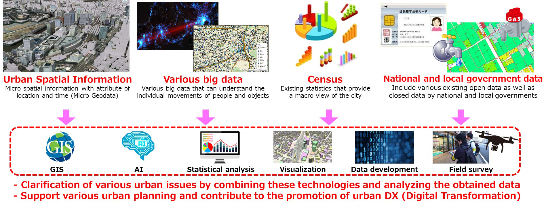
The objective of this research unit is to develop research that will lead to the understanding and resolution of various issues that occur in the urban space by analyzing and visualizing various spatial information to understand the current state of urban space using GIS (Geographic Information System) and AI (Artificial Intelligence). Various spatial information includes spatial big data, statistical information, and closed data held by national and local governments. By utilizing these results in collaboration with national and local governments, the project also aims to support various urban planning efforts and contribute to the promotion of urban DX (Digital Transformation). In the future, our goal is to create a "digital twin" that integrates various urban spatial information and reproduces the entire city in digital space, as well as a scheme to realize its utilization and social implementation.
Summary of research unit objectives and activities
Research Staff
Unit Leader・Professor
Department of Urban and Civil Engineering, Faculty of Architecture and Urban Design, Tokyo City University

Project Associate Professor
Hiroki BABAAccociate Professor
Faculty of Science and Engineering, Chuo UniversityUrban planning, Urban shrinkage, Housing policy, Spatial analytics, Urban attractiveness

Yoshiki OgawaAccociate Professor
Center for Spatial Information Science, The University of TokyoGeo AI, 3D city modeling, Remote sensing, Urban planning, Disaster prevention
Chiaki M. AkiyamaAccociate Professor
Faculty of Engineering, Reitaku UniversityEnvironmental geography, GIS, Land use analysis, Well-being
Accociate Researcher
Kotaro MizutaniDepartment of Urban and Civil Engineering, Faculty of Architecture and Urban Design, Tokyo City University
Spatial information science, Civil engineering planning, GIS, Data science
Research themes
Development of a Digital Map for Estimating the Future Distribution of Vacant Houses Across Japan Using Government Micro Statistics and Machine Learning
In recent years, the number of vacant houses has continued to increase throughout Japan, and local governments across Japan have been working to monitor the distribution of vacant houses throughout their municipalities and to develop maps of vacant houses. However, an efficient: quick, inexpensive, and continuous method for ascertaining their distribution has not yet been developed. Although there is a high demand for forecasting the future distribution of vacant houses, few methods have been established at also the research level. Therefore, this study aims to develop a model to estimate the future distribution of vacant houses using various spatial information, focusing on micro data from government statistics, which are maintained and updated based on the same standards throughout Japan. Using the model, we will then establish Japan's first highly universal method for estimating the future distribution of vacant houses that can be applied to all of Japan. The final goal is to develop a digital map estimating the distribution of future vacant houses throughout Japan.
Contact to unit leader
Professor
Department of Urban and Civil Engineering, Faculty of Architecture and Urban Design, Tokyo City University
Email: akiyamay@tcu.ac.jp
TEL: 03-6809-8547(int:3268)
Web: https://akiyama-lab.jp/yuki/
Please search "akiyama.yuuki".